10 Objectives, scope and context of the adaptation process
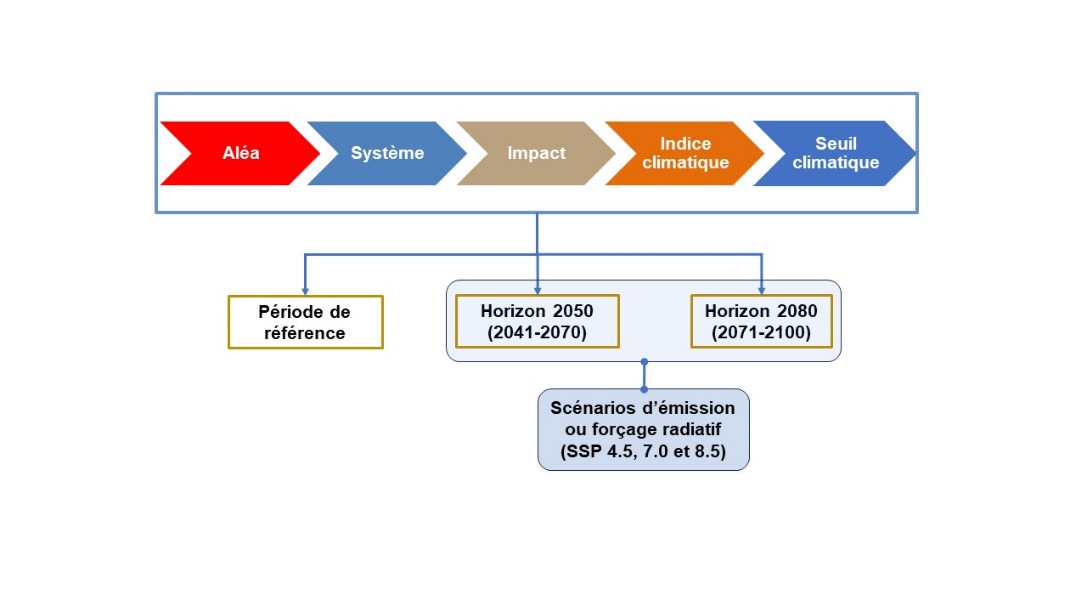
This step aims to: (1) define the objectives and scope of the adaptation process; (2) establish a portrait of the organization and the territory; (3) identify the hazards, systems and impacts to be considered; and (4) specify the parameters of the risk analysis (Figure 10.1).
Objectives and scope of the adaptation process
The fundamental objectives common to all adaptation processes are: (a) to evaluate the risks posed by climate change in current and future climates; (b) to identify adaptation needs; and (c) to define and implement the appropriate adaptation measures. The adaptation process is then summarized in an adaptation plan. More specific objectives can be defined based on local issues (e.g. issues associated with coastal erosion or forest fires).
Portrait of the organization and the territory under its jurisdiction
A portrait of the organization undertaking an adaptation process (city, municipality, urban community, etc.), as well as the characterization of the territory under its jurisdiction, must first be produced. Collaboration with other organizations whose territories are connected and those whose jurisdictions are complementary (e.g. RCMs) may prove essential for certain common issues (e.g. flood risk management at the scale of a watershed) or to coordinate adaptation processes.
Identification of hazards, systems and impacts
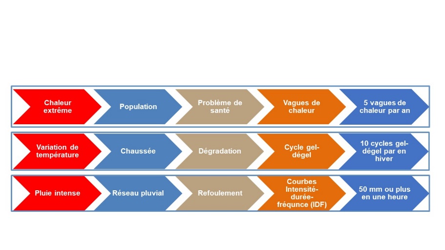
The , the affected by these hazards, and the impacts (or of these hazards on the systems in the territory are then listed. The systems in question include infrastructure (e.g. road network, combined sewer and stormwater systems), populations, economic activities, natural environments, and services1. The key hazards in Quebec are river floods (open water, ice jams) and floods caused by rain (sewer system backup and accumulation of water in urban areas), as well as heat waves, landslides, forest fires and coastal erosion and submergence2. Other hazards may be important in certain regions facing certain problems, such as thawing permafrost, air quality degradation, or droughts. The impacts of these hazards on the systems must then be listed. This means documenting the hazard→system→impacts chain based on the available historical data and documents. This exercise requires collecting information on past hazards and their impacts on current systems for the territory under study. In addition to this analysis, consideration should be given to those hazards which may not have occurred in the past but risk occurring more frequently in a future climate, and the systems they could affect. Information on the future changes in these hazards in a future climate must therefore be collected. Several resources are available for this purpose (see fact sheets 15).
The parameters of the risk analysis
A risk analysis (fact sheets 11, 12 and 13) requires the following preliminary steps: (a) identification and characterization of hazards and selection of ; (b) establishment of ; (c) identification of ; and (d) selection of (Figure 10.1).
Climate hazards and indices
A more detailed characterization of the hazards must be undertaken on the basis of the data collected in the previous step. The purpose is to define, qualitatively or quantitatively depending on the nature of the available data, the (or probability of occurrence) of this hazard in past and future climates. A qualitative evaluation will be based on the available empirical knowledge or on expert opinions. Otherwise, if historical data or climate projections are available, a statistical analysis of this data will make it possible to estimate these probabilities.
, which consist of values combining one or more climate variables, are useful for characterizing hazards when historical data or climate projections are available3. Thus, the “heat wave” hazard can be defined as the annual number of episodes in which the daily maximum temperature exceeds 30°C for 3 or more consecutive days4. Climate indices are used to establish the frequency of occurrence and to quantify the amplitude of hazards in past and future climates. They are also used as a proxy to establish the impacts of a hazard on a given system. For example, the number of freeze-thaw cycles is often used to evaluate the impacts of global warming on pavement degradation, with an increase in the number of freeze-thaw cycles suggesting greater degradation. The definition of climate indices depend not only on the hazard, but also on the system and the type of impact (Figure 10.1).
Climate thresholds
Climate thresholds, beyond which the consequences or impacts (damage, degradation, loss of use, breakdown of services, etc.) are considered significant and important, must be set. They will vary depending on the hazard-system-impact sequences under study. A threshold may, for example, correspond to the capacity of certain infrastructure, to a historical reference event, or to a point beyond which managers believe that there will be a breakdown in services. Useful sources of information for setting these thresholds include empirical knowledge acquired in the past by various groups, such as municipal employees, operators of various equipment or intervention teams, as well as the analysis of past hazards. As an example, a threshold of 10 freeze-thaw cycles per winter could be considered, above which road surface degradation would become a concern (Figure 10.2). These thresholds will be used for risk analysis (see fact sheets 12 to 13). Figure 10.2 shows other examples of hazard→system→impact→index→threshold sequences.
The reference period and time horizons
The adaptation process requires specifying which past and future periods will be considered. The reference period is the past period, preferably at least 30 years long, to which future climate conditions will be compared. This period must be recent and it must be representative of historical conditions. However, it depends on several factors, including the period for which observed data is available. The refers to the future periods that will be compared to the reference period. Two periods are recommended, to represent medium- and long-term horizons: 2041–2070 and 2071–2100.
Emission scenarios
Various emission scenarios, each corresponding to a possible future change in greenhouse gas emissions and atmospheric concentrations, must be considered. Three scenarios are commonly used — SSP2-4.5, SSP3-7.0 and SSP5-8.5 — corresponding to increasing levels of . Thus, each hazard→system→impact→index→threshold sequence must be evaluated for each of the time horizons and SSPs selected, and the results compared to the reference period (Figure 10.1). These results will be used to carry out the risk assessment (Fact Sheet 11) and to proceed with addressing the risks (Fact Sheet 12).
Appendix F of Ouranos and MELCCFP (2024) presents a non-exhaustive list of municipal systems to consider.↩︎
Appendix B of Ouranos and MELCCFP (2024) provides a list of possible hazards with their potential impacts on different systems.↩︎
Appendix A of Ouranos and MELCCFP (2024) provides a list of climate indices with their past and future climate values for various regions of Quebec.↩︎
Definition used in Ouranos and MELCCFP (2024). Other definitions are possible.↩︎